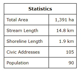
This watershed is situated in the southern half of Sea View district Darnley, the northern third of Irishtown together with small parts of Park Corner and Long River. The highest elevations of 84 to 90 m are found along the south side of the area straddling the Irishtown Rd (Rte 103) between Millman Rd and St Andrews Rd. The land generally slopes northward to the Gulf of St. Lawrence.
The Cousins Pond system has three branches that flow through the Irishtown woods and drain into Cousins Pond, a north shore barrier pond. The 3.9 km west branch starts east of the County Line Rd, flows under the road twice as it heads northeast through steeply sloped woodland. It flows through Wallace Murphys Pond and Murphys Pond before it flows under the St Andrews Rd and into Keith Adams Pond.
The central branch begins south of the Irishtown Rd and flows northward about 4.6 km to a small marsh. There is a very effective silt trap behind Lauwerijssen’s dairy farm, east of the St. Andrews Rd. The stream draining the marshland flows northeast for about 1.1 km to reach Cousins Pond.
The east branch starts near the height of land in Long River district, flows northward about 1.7 km through Wilf Campbells pond on the east side of the Irishtown Rd, then into Winston Cousins Pond, north of Rte 20 and finally to Cousins Pond. This system has much forest cover, and steep terrain.


