Satellite Technology Assisting Farmers with Environmental Solutions
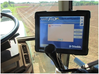
It’s an impressive site, a potato field with rows perfectly straight from one end to the other. It takes a good operator to run a potato planter, but they have some assistance in achieving those bullet straight rows. The same Global Position Satellites that provides maps for our cars and our location for smart phones is at work for farmers as well.

The straight rows help a farmer use land efficiently. If a potato planter was out by only a few inches a row, it could result in uneven rows and unused land at the far side of the field. GPS technology on the tractors and planters keep the rows square with the field, and reduce wasted space. The same auto-steer technology can then be used on the machines that cultivate and form the hills after planting, resulting in a reduced amount of sunburned potatoes, as both planter and tillage equipment follow exactly the same path. These efficiencies also mean that the amount of fuel consumes by field operations is reduced, and thus so are greenhouse gas emissions.

GPS technology can be used when taking soil samples in a field. The field can be divided up into small sections, each section with its own soil sample, leading to individual recommendations for applying fertilizer and lime. The result is that resources are only used where they are required. When the right amount is applied, the risk of excess nutrients entering our ground water and surface water is reduced.
The same GPS tools can be used in almost every field operation. In every instance, less fuel is burned, fewer resources are consumed, and the environmental impact is reduced.
Those straight rows ultimately mean that the farmer is increasing efficiency and helping the environment, with the assistance of satellite technology!

This column is presented by the Kensington North Watersheds Association and the East Prince Agri-Environment Association to inform our communities of the ongoing efforts farmers are taking toward good environmental stewardship.
